Showing posts with label trip report. Show all posts

Sunday, May 6, 2012

Buckhorn fun fest


Big Buckhorn fun fest

Just to be perfectly clear – this route is AWESOME! It’s the most challenging, varied, fun, and beautiful route I’ve done. I can’t recommend this highly enough. It has MUP (multiuse path), road, gravel, B-road and degraded double track. So sit back, relax and get ready for a long read/ride.


Beginning MUPpets
I started on the East side of Fort Collins (FTC) at the convergence of two major MUPs. There’s free parking and its pretty close to I-25. Starting here gave me the opportunity to check out the path situation in FTC and have a mellow warm up before tha major climbing began – oh yes, there will be hills.


The Spring Creek trail was pretty much what you’d expect of a MUP – it rolls and winds it’s way through residential FTC along a creek. Of course this also meant there were tons of little flying buggers I kept catching in my teeth. The scenery was easily worth it though. Starting at 7 there were folks out, but not a ton. Mostly some dedicated runners and a few folks setting up the beginning and aid stations for some race that appeared to have a later start, and of course folks walking their pets.

With Spring Creek behind me I began the ascent around the South end of Horsetooth Reservoir into Masonville where I would pick up Buckhorn Road. The temps had very quickly risen and I had already downed ½ a bottle. Fortunately this rest stop allowed me to drink a bit more and refill. I had my Skratch for the day and a few extras, so making it tasty was no problem.

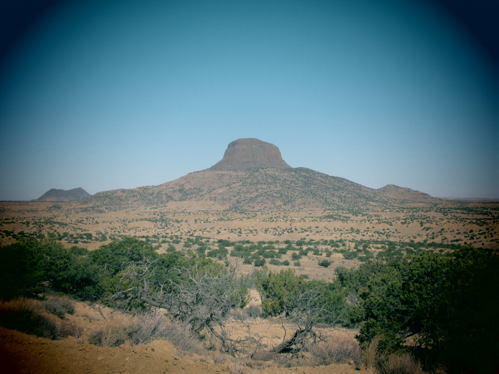
The Horsetooth above the Res

There were quite a few cyclists out on the roads up to Masonville, but they all disappeared as soon as I turned off onto Buckhorn 
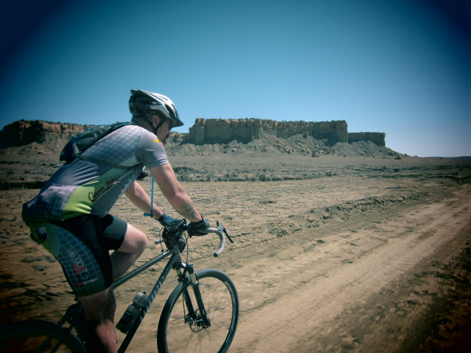
road. It’s a pity too, because Buckhorn is where the real riding starts. The first several  miles of Buckhorn are still paved (up to mile 29 by my ride) but the traffic drops dramatically, and you’re out in a much more rural and scenic valley. There’s a point where this paved road narrows and winds through a great canyon lined with rock walls.


Ok enough of this pavement
XX miles up Buckhorn road the pave road continues as Stove Prairie while Buckhorn turns West and turns immediately to gravel. This is a near continuous climb and looked heinous on the elevation profile. In reality the grade is fairly consistent and pretty gentle. Since the climb is well over 10 miles to the ranger station at the summit, you’ll have plenty of chance to soak up the scenery. Many of the Aspens has their summer coat of lush green quaking leaves. The aspens early lush growth and Columbines made the verdant climb easy on the eyes.


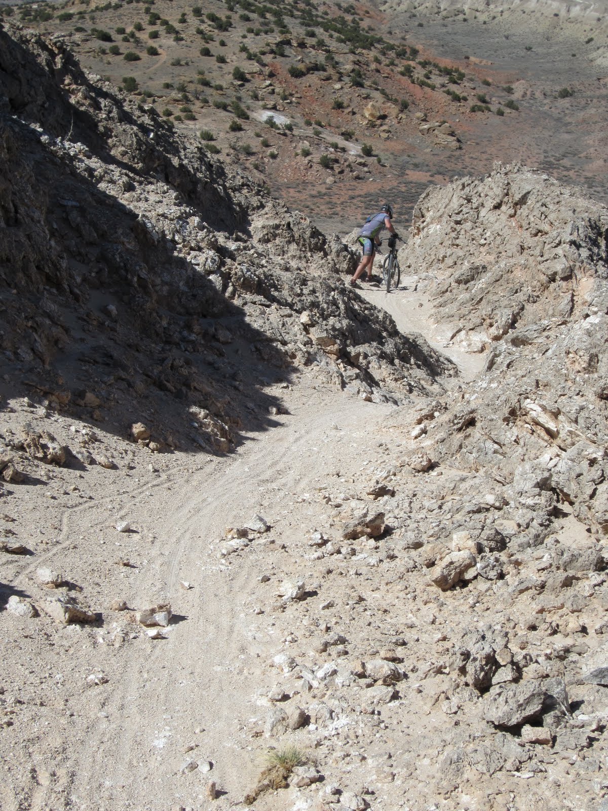
Just past the Buckhorn Ranger Station I turned right onto Monument Gulch Road. There is an immediate gate stating that this road is closed – to cars. It’s still open to bikes all year though. This is less than a B road since it’s falling into complete decay. While it’s mostly decayed double track, there are parts where it’s more of a clear path through the woods than an road at all. The beginning ¼ of Monument Gulch is over 8000 feet, it’s not overly steep but it is uphill and I’ll admit it was kicking my ass. It’ would certainly be a bit easier to climb on a MTB. Once you pass the initial uphill however it turned into an HUGE payoff. This thing was just pure unrefined fun! The fact that it’s a lesser road and a bit rocky meant I had to go slower on my bike than on a MTB, but honestly it was probably more fun because I had to pay attention more. On a MTB it would be fun but pretty mellow. There are a couple of different options near the top of Buckhorn road, but this is in the NOT TO BE MISSED category. It’s SO MUCH FUN!


The end of Monument gulch connects to Pingree Park Rd (CR 63E). This looks to be a steep drop to the Poudre River, but appearances can be deceiving. As big drops on gravel roads go, it’s damn near perfect. The roads are wide enough to accomodaye traffic, it’s mostly well packed, there are plenty of long open sections where you can open er up and enjoy the downhill speed, and where you encounter switchbacks and sharp turns they’re well signed allowing you to scrub speed. It doesn’t hurt that the scenery along here is pretty amazing too. Yeah I know I’m gushing here, but there were so many times on this road I was just in awe of how great this was. I’d say perfect compared to any of the super steep, loose, twisty descents I’ve done outside Boulder where you’re on the brakes almost constantly.

Down at the Poudre River it was uphill on a gentle paved road for 5 miles. Fortunately this goes pretty quick as there’s little shoulder and plenty of traffic on a gorgeous weekend.


The Climb - Part Deux
The turn onto Manhattan begins the second major climb into Red Feather Lakes. By this time you’re near 5000 feet of gain already and about to get a few thousand more. Unlike the climb up Buckhorn, the climb here did NOT feel like a gentle grade – it’s steep. I’m sure the prior fatigue had something to do with this, but the grade is steeper. There isn’t much I can say about this other than that it was a heads down, panting suffer fest. My legs had began feeling tired/sore around mile 25 and I had no idea how the day would go with an ominous beginning like that. Now after climbing 7000 feet in 62 miles I was feeling pretty toasted.


Red Feather Lakes
There is a flat-ish rolling section near the top as you roll into Red Feather Lakes. This was the ½ way point for me and the opportunity for a rest and water refill. The Trading Post is to the East as you roll in, and the General Store shown on the map is to the West. However since the General Store was closed for business I went trading. The toughest decision here was weather to grab an ice cream or small bag o chips – I went for the salt.


I took Hiawatha to Creedmore lakes Road out of Red Feather Lakes. Passing along the lakes is a nice ramble through residential areas and craggy rocky hills. There is a point (I believe where Creedmore turns right instead of straight and becoming Huron Rd) where Creedmore turns into more of a B road and begins a long descent. This was the second highlight of the trip. This is another super fun fast downhill section. It’s nowhere near as rugged as Monument Gulch, but it’s still incredibly fun. This is not a smooth maintained gravel, but semi-packed double track and roughly follows Bull Creek downhill. I spooked a Moose somewhere in here as I speed down through Aspen and Pine past rocky meadows and on toward my destination.


A change in scenery
There’s an option to continue downhill on 82E or tun north on CR179 (Prairie Divide) an connect with Cherokee Park Rd. I took the latter option. This pretty quickly becomes an wide open prairie. This option trades the craggy rocky tree lined views for sweeping vistas and glimpses of the peaks in RMNP.  Farther East the alpine prairie changes to provide views of craggy cliffs as you get closer to the prairies. A few rolling hills and open plains later and you briefly connect with 287 near Livermore. Rather than going into Livermore I rode out on the plains rolling the incredibly smooth red dirt of CR80 towards an unnamed reservoir. Early in this section there was a gorgeous large Rattler sunning itself on the road. Since I was past the century mark, getting really tired and I already had a snake picture I took earlier on Monument Gulch, I passed.


Back on pavement
The first glimpse of pavement comes at Buckeye where I turned South. This doesn’t last long (one block really) as most of the Buckeye Lateral was dirt. However, The pavement comes again when you pick up 287 into FTC. I was a really getting tired at this point and mostly cranking hard in an effort to finish. However I was surprised to find that I was able to average well over 20 mph on this section of the route. Sure it was slightly  downhill, but I felt fried and food was getting harder and harder to eat.

9  hrs
That seems to be the mark for me right now. Nine hours is where it starts to get hard to eat. The gummies which were easy to swallow start to taste horrid, and even the solids are hard to eat. As it happened in the AntiEpic I had to really begin forcing myself to eat. I still had ~25 miles to go and knew I would need the energy. I’m not sure why this happens, but I hope it’s something I get past as my body gets used to working this hard for this long. I know my performance diminishes when I’m eating less, but really EVERYTHING starts to taste awful, I lose my appetite and really do have to force myself to eat.
I did have one minor issue which didn’t help – I forgot my rice bars. I took part of Friday to make a fresh new batch and made sure to not burn the bacon this time. After cooking, slicing and wrapping the bars I even placed a post it note on the front door to grab 8 bars. Clearly I need larger neon writing as in my 5 am stupor I missed the note and only realized my mistake 25 minutes away from my house. I had my waffles  though and a quick stop at a gas station in FTC supplied me with some wildly over priced Cliff and Power Bars. I really could tell a difference on the ride. They simply do not digest as easily as the rice bars. They’re fine for climbing, hiking, or other lower intensity activities but on the bike I need something different – something less engineered.

Home stretch
The paved roads for 10 miles connect to the end of the Poudre River MUP in Laporte, CO. I didn’t realize on the route that I was to pass through Bellvue, CO (or even that it existed) till I was there. The one outstanding this about this tiny community was the bright yellow cafĂ© and coffee shop. It is the one place I was seriously tempted to stop and if I’m ever in this area again (of course) I’m making that a destination. The Poudre River MUP was again as expected but if anything faster than the Spring Creek. There was an interesting highlight as I rolled over a bridged section for a couple hundred yards. I was really ready to be done at this point though. It didn’t help that the ominous clouds I had seen earlier had made things seriously blustery.  I don’t know what direction they were coming from, but I can say that for the last 20 miles the wind was not in my favor. In general the wind had been quite mild with only some minor headwinds down the canyons – nothing to really mention though. In general the wind had been still all day until the weather arrived. 

Earning it
Back at the car I was pleasantly surprised to arrive 2 miles before the Garmin thought I would (where did  it think I parked?). Whenever I go to FTC I have a hard time resisting Rasta Pasta and their signature dish. This was no different. I had planned up to 12 hours and finished in under 11 so I certainly earned it this time. I had, if truth be told, been craving that spicy jerk chicken pasta goodness for the past three hours. When I could barely choke down a waffle it might partly be because I was fixated in a spicy pasta.

I’ll end as I began – this is a FANTASTIC route! If you’re not into the MUP then change the beginning (I probably wouldn’t do that a second time). However, if you love the scenery around rural mountainous Colorado than the Buckhorn/Monument Gulch/Creedmore Lakes elements are not to be missed.  

Tuesday, April 24, 2012

Swiss miss-ive

A few weeks ago Adam and I attempted to do the Switzerland Trail (see Swiss Recon). We got stopped by snow, so I took a second go at doing the entire route as an opportunity to test some gear and work out a recent knee issue I had developed. The Switzerland trail can be divided into four segments that look something like a backwards "L". Three of these run north/South and the last cuts West to connect with the Peak to Peak Highway.


After rolling by Spruce Confections to fuel up on espresso, I headed to Boulder Canyon and up Four Mile Road. Instead of continuing to Sunset, as Adam and I did, I hooked left on Logan Mill Road to do the three main portions of the Switzerland Trail. Logan mill eventually connects to Sugarloaf Rd, via the Escape Route. There are a couple of unmarked turns on this road, so I was happy to spin a few miles with another rider who knew the way. Chris was from Boulder and planned a slightly different route. After I told him my plan Chris had mentioned that the northermost portion of the Switzerland Trail, wasn't really CX bike territory given that he had turned back on this full suspension rig. This was the potion under snow when Adam and I ventured up here last, so I didn't know what to expect. However, I was out for an adventure so I thought I would take my chances and turn back if need be.


The first leg of the trail was all downhill into Sunset. On a mountain bike you could probably bomb down this thing pretty fast, but the rough road, many rocks and CX tires meant I had to keep things pretty slow and pick a good path if I didn't want to completely wreck my wheels. As it was there were more than a few times I would have pinch flatted if I wasn't tubeless.

Leg two runs from Sunset to Gold Hill Road, and is the segment I had ridden previously. I ran into no snow and no other riders on this gorgeous sunny day. What I did see were more than a few motorbike folks and people walking their dogs.

Leg three runs North from Gold Hill Rd almost to the town of Ward, CO. It's the part that Chris had warned me about. Surprisingly, the first couple miles of this leg were the smoothest part of the trail I had yet encountered. This didn't last though. There is a fork at one point where a sign indicates the main road dead ends. It was here I saw the moto folks coming back - I suppose it did end for them. After 1/2 mile or so on this section I came to some reasonably long stretches of talus that you need to ride over or walk. I'd certainly prefer my fatter 29er tires, but I didn't have 'em and made do. No flats, nothing too scary, and I made it just fine with the 35c tires. What's "too difficult" is pretty relative. There are plenty of places I'll get off and walk, where other folks feel fine to ride.


There is, however, a very brief segment at the end of the trail (perhaps 75 yards) where you will have to dismount any bike. This little connector trail hooks up with Sawmill Road for a brief stint before you pick up pavement into Ward. This was my first time in Ward and it was nice to see that the general store seemed to be a haven for cyclists. Several were leaving, and several others were lounging on the veranda. Of course, all were on svelte road bikes. From Ward I picked up the Peak to Peak Highway heading South to find Gold Hill Road. I headed on the rolling road - crossing my previous path on the Switzerland Trail - into Gold Hill for a stop at the general store. This was my 1/2 way point at 50 miles and I added water to my bottles and  a tiny bag of malt vinegar and sea salt chips to my belly.

Back in the saddle I continued downhill on Gold Run Road to reconnect with Four Mile. The steep descent meant it was quickly time to turn back up and begin what seemed like the longest climb of the day. I climbed  up to Sunset and hooked left to retrace my steps on Leg 1 of the Switzerland trail so that I could finish the last segment that goes West to the Peak to Peak. This entire stretch is uphill and seemed to go on forever. It wasn't so much the elevation or the distance as the slow going on the trail. Of course the payoff included some great views.


The Peak to Peak took me through Nederland and on to Magnolia Rd where I planned to head off the hill. The toughest part was deciding whether to stop in Ned for a little Caffeine fix. I might have helped, but I decided to pass and just continue on. I had been looking forward to the downhill into town on Magnolia, but  I didn't know was that it's still rolling hills for a while. Only after this do you get a screaming descent for the last 4.5 miles. Fortunately those miles are paved as you build up speed quickly and there are quite a few sharp turns. There are also some sandy patches which can put an end to a day quickly if you're not careful. The many curves meant I had to stay on the brakes a lot and couldn't open it up and fly.

The remainder of the route down Boulder Creek and following bike paths home was inconsequential and familiar. I was sad to see that my elevation was so close to 10,000 ft (9971 by my Garmin) but there are no hills anywhere on the way back to my casa. (Strava robbed me of another few feet and only shows 9921 - bastards!) Something about climbing 10k seems like a magic threshold that is more than the missing 29ft.

Overall a good day and a great route. If you're in the area and looking for a century with some big hills and rugged miles check this one out - just find another 50ft hill somewhere to make it an even 10k.


Wednesday, April 11, 2012

Audio trippin - AntiEpic and underground races

Ben interviews me about my experience in the AntiEpic, opinions on rides and choice of gravel weapons.


Listen to internet radio with Mountain Bike Race Minute on Blog Talk Radio

Monday, April 9, 2012

AntiEpic - trip report

The AntiEpic gravel grinder. This race really rubbed me the wrong way (see below).


Odyssey, quest, journey, jaunt
While we all took nearly the same route, the personal journeys were quite varied . We all froze in the early am 28 degree start and we all battled a viscous wind,  but some elected to take a shorter path (100 mile route), some added a bit extra to stop and resupply food/water (+3 to Deer Trail), some wrestled their flat tire demons (at least one guy had 7 flats), and I'm sure there were also plenty of inner demons battled in the gravel arena.


Cock-a-doodle-do!
After a 4am wake up, 15 minutes to get in the car, and a quick stop in Boulder to pick up Adam, we were on the road to begin our journey. The temps dropped from 40 at my house to 28 at the race start. I wore what I had and it was thankfully just enough. While the sun was supposed to shine bright all day, I checked on Larkspur, Kiowa and Deer Trail and the weather prophets predicted it would not get much above 60 for the high. This was just within  range to wear my leg warmers and long sleeve jersey all day. I had purchased a Jandd seat bag which gave me room (2-3 L) to store extra food then later stuff my jacket in there. While I didn't overheat, I did freeze a bit in the morning. With my warmer gloves on and lighter pair in a pocket I had numb fingers for the first hour or two. Long after my fingers returned I began to feel my right toes. My left ones were slow to catch up - it took about 60 miles for them to reappear.


I lugged a camera around for 161 miles and took only 1 fuzzy photo at the start. 
The group did a neutral roll out for the first two miles to where the official end was supposed to be. Then Ben gave the word and the actual race began. The lead group was cranking fast and I didn't make any attempt to keep up. I rolled casual for a couple miles chatting with Ben before getting into my own pace. I still kept the lead group in sight for the first 40 miles but slowly fell further and further behind. A few folks passed me, some of which I caught later. A few other folks from the lead group began to slow to their own paces and I rode with some of them and overtook others. I had planned to mostly ride at my own pace and not deliberately spend too much time making this a social ride. It didn't take much effort on my part for this to be the reality of the day.

This blows
The route began by heading East and then curving North to a high point where we turned back due East to head towards Deer Trail. The due North segment flew by. The road was in near perfect hardpack condition and a slight tailwind made it easy to push well over 20mph without much effort. As soon as we turned East, however, the casual ride was over and the battle begun. The rest of the day was spent fighting a solid headwind or cross wind. This added tremendously to the effort involved to push through this route. The wind can be incredibly demoralizing. I'm honestly not sure whether the headwind is harder than the cross winds. I had done the pre-ride with Ben a month before and two other rides out here solo, all of which avoided any serious wind. There is only a very small segment of the entire route that has trees to abate the gusts, but I was thankful for their brief respite.

Oasis 
The hardest decision I made to prep for the route was whether to stop in Deer Trail. This would allow me to just bring three bottles and carry less weight, but added three more miles and one more hill climb. I figured about 20 minutes to be added. I really didn't want to lug an extra gallon of water and don't enjoy riding with a pack, so I elected to stop. It was a good call - I would have needed the break and the facilities regardless.

Since Deer Trail is at about the 80 mile mark, I planned to reapply my chamois cream here. Sadly it was nowhere to be found. (I did find it on the dashboard of my car at the finish.) Let's just say I did A LOT of standing for the last 60-70 miles and sitting back down on the saddle was really starting to hurt. My legs were certainly tired from pedaling, but in the end (pun fully intended) the AntiEpic really chapped my hide.

We did have some news that the snow earlier in the week had left the three-mile B road in "VERY" muddy conditions. Luckily the wind and sun of the last few days had dried it up nicely. The surface was soft and a little sandy so it was a little slower, but honestly it was pretty tame.

Difficult to swallow
Food was an evolving interesting thing on this ride. I went with my normal rice bars and waffles on the hour and gummies every 15 min between. This worked well for ~125 miles. Then for some reason it just got harder to eat. The gummies, which really only take 3-4 chews and 10 seconds to eat, began to taste awful.  I'd endure about 5 minutes of them somewhat dissolving in my mouth before swallowing. Chewing the rice bars or waffles seemed like energy I could't spare from the pedals. I knew I needed to keep eating though and I did - up until the last 45 minutes. At that point it just became en effort to get to the end. Another rider I was near or with from mile 60-about 115 mentioned being in "survival mode" beginning at Deer Trail. I wasn't quite there (probably a few hours from that) but I didn't feel too far off.

There was brief tease near the finish. The technical route ended about two miles from where we parked. The last 1.17 miles headed to this line are due North (ergo the only tailwind in the last 100 miles of the route). So I'm not sure how fast the wind was blowing but that list mile - at a slight uphill - went something like this: Pedal twice, stand and cruse for 1/4 mile, pedal twice, stand and cruise, look down at computer (27.4 mph!). Then I rolled up to an empty lot :( I know what happened. They're at the parking area. I could swear I heard weeping and a violin at that moment. It's only two miles and it's mostly downhill but it couldn't go fast enough. I had been out for 12 hours, and the heat of the day was fading fast making that wind colder and colder.

Fin
Back at the car I found Adam who had elected to do a slightly shorter 100 mile version of the course. Fortunately he hadn't been waiting too long for me and had been able to take refuge with others (I had the only keys to the car). All my energy was gone at that point and I got out of my kit and into dry clean clothes pretty immediately. I had on a heavy fleece, fleece beanie, and a windproof insulated jacket with the hood up but I couldn't stop shivering. I should have been plenty warm enough, but my body just didn't seem to be generating any heat. I said a quick hello to Ben and some other folks waiting around (Ben's wife Amy and Eric whom I met on the B road). Adam and I made a quick exit to get some calories and headed to Larkspur where we had spotted a pizza joint. A Greek-ish pizza with olives, artichokes, feta and pepperoni was probably the worst recovery meal I've had yet. We ordered the 18" but just eating the first slice felt like work. I made it through a second, but had to stop there till I made it home (by which point I began to feel slightly human again). Somewhere around 5 minutes after sitting on the couch I passed out. Then woke at ?am and stumbled into bed.

Coda
Previously my longest ride was 106 miles in the High Cascades 100. This was 161. I'm fairly amazed at how well I feel less than two days later. It may not have been the best idea to plan a multi-pitch climb that involves and uphill hike in, for the day after an event like this, but some how that's what I did. I was fine, and had a fantastic day. I really felt exhausted after the ride and pretty beat when I first woke up, but it didn't last  long. My current training seems to be working great, and while my muscles feel tired and won't be fully recovered for a week, the only pain I feel is in my face. You see, I neglected to put sunscreen on my face, so now I have this lovely raccoon tan/burn.

Tuesday, April 3, 2012

Soapstone Prairie and Red Mountain


I had been wanting to explore Soapstone Prairie Natural Area for a while. Since one of the longer sections of trail is closed from April 1-July 15 my ride on March 31 was a timed perfectly. I planned just over 30 miles and around 3 hours. 


The parking was easy to find and access with plenty of room. The SPNA website never mentioned a fee. Since the entrance kiosk was unmanned, and there was no signs for fees I was happily surprised to find that this was a free use area - not many places seem to be anymore.


I began heading East to connect with the Plover trail. This 7+ mile section is closed for a few months to allow for nesting. The trails leading to this were pretty fun, albeit mellow, singletrack. The Plover trail itself however, wasn't a trail so much as simply a gravel road on the plains. 


After rolling North on Plover, my route headed West. This was a fantastic trail that was almost entirely double track. Still the scenery was lovely. I began to catch up to a few recreational riders in this section. After a short wrong turn diversion, and correction, I saw them again as the trail entered the Red Mountain Open Space area.


The beginning of Red Mountain Open Space - looking South

The route - Ruby Wash - heads right down into that  canyon.


Red Mountain is a big change in scenery as you drop into Ruby Wash. It's the first real singletrack on the route I chose and the first area where a CX bike might not be a better option. This is even more apparent when you finish the descent and end up in the wash proper. for those not in the know this means you're riding on a dry sandy creek bed. It's not a ton of fun, and it is sluggish, but the scenery of riding through the canyon makes up for it (at least the first time). Along this South heading section of the route the trail was marked with nondescript little towers of rock held together in a wire shell. They're not always easy to see, but that's what you're looking for if you go here. The creek bed wanders and there are tire tracks all over. There are also several random side trails (some of which go nowhere) but the towers point the way.


The wash part of Ruby Wash


At the end of Ruby Wash it was time to head back East to reconnect with the car. This unfortunately meant I had to head up another wash (uphill this time). At some point I exited stage right onto a very clearly defined singletrack section. I wish I had taken some pictures of this section because it reminded me of Salsa's line "adventure by bike." I'm not sure if this was a sanctioned trail, as it had varying use and was unsigned, but it was prominent, nothing told me not to ride it, and it did connect with another main trail. (FYI - there are many different places where trails are clearly marked with signs that say "Not a trail.")


Back on the main trail, singletrack dominated the remainder of the route. The Cheyenne Rim trail was fantastic. The views were amazing and after one large ascent it was largely downhill. I couldn't help but think that I was on this trail in the right direction. The last mile to the car was double track but the other 6 miles were the highlight of the trip.

How Cheyenne Rim got it's name

sweet singletrack = more fun riding and less pictures

I hadn't found anyone else who had ridden here, so I wasn't entirely sure what I was in for. Now I know and I can say I would go back. I'm generally not fond of gravel on a MTB ride, and I could do without so much sand next time, but there were several sections of singletack that I missed on this trip which could be linked together to avoid a lot of the sand and most of the roads. There is very little technical riding in this area even on the singletrack, but what there is leads me to believe that this is still a lot more fun if you bring the 29er and leave the skinny tires at home. 


Monday, March 26, 2012

San Ysidero Dirty 104


The San Ysidro Dirty Century was my first race this year, and a unique event. The SYDC is mostly a gravel race with a “short” section of singletrack. Historically the course has started and finished from a brewery in Rio Rancho, New Mexico. Due to land access issues there were some last minute course changes. Much respect to Lenny Goodell – the event organizer – for pulling together a great backup plan. In reality, this was probably a better route. (Here’s the route on Garmin) Previously the full version of the course was 123 miles, but the revision reduced that to 98. However, this placed the singletrack at the very end of the course – a devious sting in the tail. Hoping to bring the Mosaic I asked Lenny if this singletrack was CX bike friendly. Here’s his response:
Hey Shane, this is from Chris Hereford who always does SYDC on SS CX. Also he is a very good technical ride, so he may have a different view of White Mesa on CX than others…
“CX bike is the only way for SYDC. The singletrack isn’t severe enough for an MTB. Just my opinion, after five years on a cx bike on the course. And this has all been on a SSCX bike with 42×18. Suspension isn’t necessary for the long day, but many enjoy the comfort of an mtb. Yes, it is mostly dirt road, with occasional sand pits, and that’s when I’ll have to walk sometimes.”
That sounded positive to me. The videos and photos I had seen of the White Mesa trails seemed to confirm that it was mostly flowy mellow trail with just a few rocks tossed in.

Ok, so how did it go?
The day dawned bright, crystal clear and 50 degrees at 7am. After some rushed preparation – my phone/alarm decided to crap out – I was ready to go. The check in and line-up was pretty informal. Lenny called the start and we were off. The lead pack blasted ahead pretty quickly. I managed to keep up for the first 7 miles or so, even leading for a brief ½ mile. This group was going really fast (around 18mph) and I knew I wouldn’t be able to keep this pace all day. I fell slightly back just before we turned right on Pipeline Road. This was also the point where we faced a bit of a headwind and I was really wishing to be in the paceline to draft. Alas, this was not to be and facing the headwind alone I fell farther and farther behind. The group was still in sight however until I made a wrong turn.

Lenny starting us off.

Horse play on Pipeline Road. 

A very generous soul was kind enough to drop water and whatever else we wanted about the 18 mile mark in the course – a point where we turn right, make a big loop and reconnect at about 65 miles in.  The drop ended up being closer to the 15 mile mark at a different intersection where we were to turn left. Something felt off but a local I was riding with assured me we were to go straight. Then the Garmin told me I was off route. There were not a lot of tire marks but I did see one rider ahead and three others joining us behind. I asked one who also assured me we were on route. Things didn’t seem right by the mileage when I checked the cue sheet. After asking about the Ridge Road intersection I confirmed that we were indeed off route about 3 miles. I told this to the others around me. They elected to continue on, which would have reduced the distance by ~5 miles, while I turned back to get on the official route and add 6.

Back on the official route and trusting the course in the Garmin all pressure was now off. I was previously struggling in my attempt to keep up with the lead group, but with the added 6 miles and whatever distance they covered I was likely at least 12 miles behind and completely unable to catch up.

Ridge Road
Had I stayed with the shorter course I would have missed ridge road, which was a fantastic a scenic stretch I’m glad I didn’t miss. I took it super easy and rode a couple of very mellow miles chatting with another rider, Charlie, before opening it up and going at my own pace. This big loop of the course wraps around Cabazon Peak. 

Cabazon

After a brief 4 mile paved section I was on the North side of the peak and passed a large group who I later learned had also gotten off route. One rider from this group, Billy, caught up to me and we ended up riding and chatting for most of the rest of the route. I made the decision after my “bonus” miles that I would take the time to be a be a bit more social rather than simply try to keep my own pace the entire ride. I probably could have finished faster had I gone at my own pace the entire time, but I would not have had the same experience. The people I met on the SYDC made the experience special for me at least as much as the fantastic weather and the amazing views.

Billy on the drop bar Niner. I was coveting that fork on the singletrack. 
Billy was on a single speed, drop bar, 29er with skinny tires. I’d often move ahead on many descents and Billy would catch up later. While I can often keep up on the flats, Billy and many other experienced riders always jet past me on the hills. With only 18 months of riding under my belt and only 4 months of actual training it’s becoming rather obvious where I need to focus my training efforts in the future.  For now and the rest of this season I need to focus on my endurance, but hill climbing will be the training menu for next year.


Billy and I finished rounding Cabezon and returned to the drop. After a quick refill, we headed down the last 15 miles before the singletrack. I went off on my own from here at my own pace. I had played tag with a woman on a full sus 29er for the last hour or so. I called tag when I caught here again and sped past down the road. Near our last turn at the natural gas compressor station I met Todd and his squeaky wheel. Todd had kept up with the lead group till a broken spoke and a wounded wheel led his tubeless setup to fail. As luck would have it his spare tube had a broken valve and Todd was forced to hike till another CX bike caught up with a spare tube. He and I rode into the White Mesa Trailhead where he split off to finish and I elected for more punishment. Todd had kindly offered a place to stay in Santa Fe for the night, but losing his number and my dead phone nixed this option.

I rolled into White Mesa at just under 6 hours and around 90 miles. Expecting the last 15 miles to be fun and mellow I figured one water bottle to be enough (big mistake). I wasn’t on the trail for more than 2 miles before I had slowed to a crawl. I was pretty obvious even in this early part of the trail, that while you could ride these trails on a CX bike, it was far from a wise decision. (From what I can tell I was the only fool to ride it on a rigid CX bike this year.) After this first two miles I heard a fast rider come from behind and yell “Tag!” I knew I wouldn’t see her again. Billy caught up shortly after that and we both endured the remaining miles together. Billy had ridden this trail system at least twice before and his wayfinding experience was extremely helpful. White Mesa has a fantastic map at the trailhead and promises numbered intersections with maps at the junctions. Well, some of the junctions were numbered and had those maps, but others were vague. We finished off the route and rolled into the finish together – not DFL. Ironically the first 90 miles took 6 hours while the last 15 took 3.


A true ridge route

Just some of the exposure.


Yup, we came down that amazing trail on the ridge.


The trails at White Mesa are amazing. They really differentiate this route from all other grinders that I know of. The views and exposure are fantastic and scenic, but there are quite a few steep ascents and descents, a lot of rocks, a bit of sand, and the sections which could have been smooth had dried to cement like hardness with many dips and potholes. This was beating me up for the entire 15 miles. It was easy to enjoy the views, but honestly it was hard to enjoy the actual ride on this bike. I’m glad I did it, but wish I had the right bike. (FWIW a hard tail 29er would be perfect for the full ride – I just don’t have one. I have a double squish, but thought that would be overkill on the road. Any time I lost there I would have easily made up on the singletrack.) There’s a reason the vast majority of folks were on mountain bikes. I realized that Chris Hereford (the guy quoted above) really is a complete bad ass.

Climb-a-bike. It's not just a steep gully. The rock Billy is standing on requires some scrambling just to get up on. 


Billy is about 200' below me on that sandy, steep trail.


At the finish I connected with a couple of other Colorado riders Aaron and Phil. I had filled a growler at Oakshire with their Overcast Espresso Stout (my personal favorite) before I left Oregon. I had been looking for an occasion to open this thing and I was certain this was near the end of the shelf  life. I can't really drink more than 2 oz of beer after a long ride, so sharing this at the end of SYDC seems like a good choice. Sadly, some combination of the extra time in the bottle or the extra heat in the back of the car meant that the beer had turned. A quick sip confirmed that. I went to dinner with Aaron and Phile where we replenished some lost salts with the salty rim of a margarita. After breakfast at the Bad Ass Coffee Co we both headed for home, but coincidentally reconnected in Trinidad, CO where I had stopped for lunch.


The cage for this bird is about 15' tall. 
There are many great old buildings in Trinidad, but many appear abandoned. 

Lessons learned: 
  • If you don't put sun screen high enough on your forehead you get little triangle tan lines. 
  • Sun sleeves work fantastic, but slide down in the back sometimes leaving an exposed strip (yup got a burn there too.) 
  • Some really cool people do these rides. 
  • The route loaded in the Garmin is sometimes more accurate that advice from locals.
  • Don't bring a butter knife to a sword fight. 
  • Dark beer lasts a while in a growler, but not six months. 


The AntiEpic is in two weeks. I know the roads there so I’m safe on the Mosaic. I’m hoping to pull off a White Rim trip in another two weeks after that and call it a training ride, but on the 29er.